Know your risk. Focus your resources. Protect what matters most.
Scientifically validated wildfire hazard and risk assessments, from county-scale planning down to individual parcels.
Identify where to act, and confidently prioritize the work with the greatest risk reduction outcomes.
Trusted across the industry

.png)
Three decades of best-in-class wildfire risk modeling, driving risk assessments and mitigation decisions communities rely on.
Pick the right solution for your community
Our readily available datasets help you assess wildfire exposure and risk specific to your area of interest.
Each includes varying levels of hands-on support. Contact our team for specifics.
Wildfire Hazard Assessment
See where fire is most likely to start, spread, and challenge suppression efforts. Communicate hazard clearly to communities and build a stronger case for action.
See an Example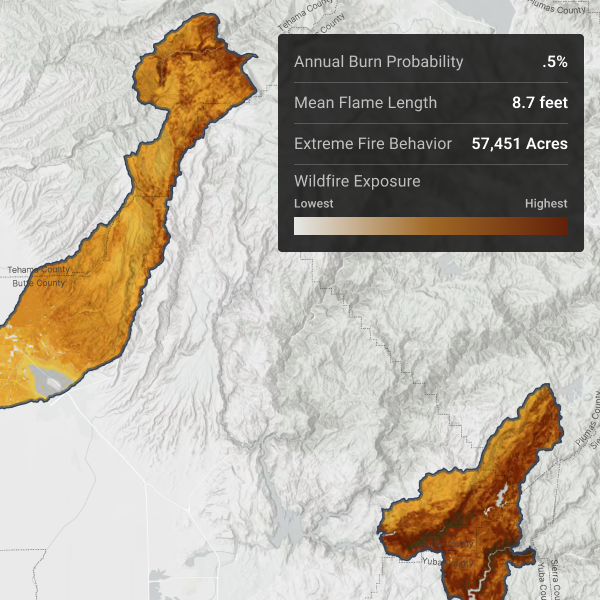
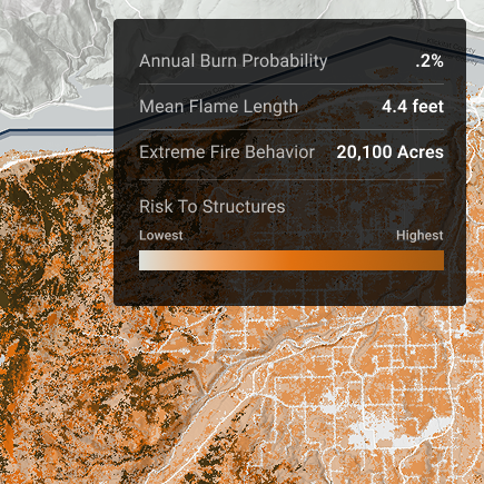
Quantitative Wildfire Risk Assessment (QWRA)
Go beyond hazard mapping. The QWRA layers risk onto the Wildfire Hazard Assessment — revealing how homes, resources, and other values you want to protect will be impacted by wildfire.
Use your QWRA to drive action, refresh your CWPP, and meet CEQA and NEPA obligations.
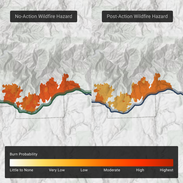
Wildfire Mitigation Planning
Quantify how specific treatments reduce flame length, embers, burn probability, risk to your assets and more. Prioritize action, optimize your budget, and back every choice with data.
Best paired with the QWRA and built to support your CWPP.
Looking for end to end wildfire risk management?
Explore the Vibrant Planet platform: comprehensive Pyrologix wildfire modeling, prioritized risk mitigation planning, and post action outcomes reporting - all in one place.
Additional Solutions


(Why is probabilistic modeling important? Read more below)
Not sure which solution is best for you? We’re here to help.
Get in touch to learn more or request a sample.
Pyrologix is the leader in proven, rigorous wildfire risk modeling
.png)
Frequently Asked Questions
What is wildfire hazard?
Hazard measures physical landscape characteristics – how likely fire is to occur, and how intense it will be. It looks at burn probability and fire intensity together.
What can I do about my wildfire hazard?
If you’re just getting started, Vibrant Planet’s wildfire hazard assessment helps you get a snapshot view of hazard on your landscape.
What is wildfire risk?
Risk combines hazard with what’s at stake – evaluating what fire would do to the homes, assets, and resources you care about.
What can I do about my wildfire risk?
Our Quantitative Wildfire Risk Assessment is a great place to start understanding how hazard impacts the values you care about protecting on a landscape.
Take it further by building a Wildfire Mitigation Plan, which helps you start planning treatments to reduce that risk.
For more iterative and collaborative planning, Vibrant Planet’s Platform is the most comprehensive solution.
Which models drive Pyrologix's wildfire analysis?
We have developed and maintain three core models:
WildEST - Shows you exactly how fire behaves across your landscape. The power of WildEST lies in simulating across the full range of weather conditions, not just the average. Give your community the data it needs to prioritize treatments, harden homes, and plan with confidence.
Pyrosity™ - Determine the most critical locations to disrupt fire spread. Pyrologix's custom corridor-mapping tool identifies the most dangerous pathways fire can travel into your community. Stop catastrophic spread before it starts by acting on the right flow paths first.
FullSim - Model the full spectrum of wildfire scenarios, including catastrophic events. This next-generation simulation system extends publicly available fire modeling infrastructure and generates thousands of statistically grounded ignition, spread, and consequence scenarios across your landscape. Understand your true wildfire risk — from the likely to the disastrous — so every decision is backed by science.
Why does Pyrologix use a probalistic risk model instead of a single fire simulation?
While a scenario-based simulation predicts how a single fire might behave under specific conditions, a probabilistic risk model acts as a strategic map for your entire jurisdiction. By aggregating thousands of simulations across diverse weather and ignition scenarios, our model captures the full distribution of potential outcomes — from the most frequent moderate events to rare but catastrophic extremes — and quantifies the average annual risk to every structure or asset across your landscape.